Group B, Poster #112, Earthquake Geology
Quantifying the erasure of earthquake surface ruptures from desert landscapes: Implications for rupture hazard assessment


Poster Image:

Poster Presentation
2024 SCEC Annual Meeting, Poster #112, SCEC Contribution #14031 VIEW PDF
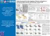
upture styles and rock types. We apply a 2D linear diffusion Landlab model to the initial DEMs to simulate the effect of surface processes at 100, 1k, 5k, and 10k years since the scarp-forming event (with a transport rate of 1 m2/kyr). We map fault traces and compare the slope distribution from both the original and diffused landscapes at each time step. For each time step, we also measure the fault trace lengths to quantify the reduction in mappable length due to erosion. To measure how the landscape smooths over time as a proxy for information loss, we compute the ratio of the mode of initial slopes and mode of the slopes in the diffused landscape (“degradation coefficient”). In March 2024, we performed field validation with ground and UAV surveys of select ruptures at the Ridgecrest site. Our results demonstrate that diffusion over longer timescales erases secondary fault traces and obscures the primary fault location. Only 20-70% of the original fault trace length remains mappable at 10k years. Our models show that the degradation coefficient of the landscape increases rapidly within the first 100 years of diffusion, then gradually increases for each subsequent timestep. The modal slope of the entire landscape decreases with time. Depending on the complexity of the landscape and the fault morphology, there is variation in the rate of change of the line length loss and degradation coefficient. Simple single-stranded fault zones show less line length reduction with time. These results suggest that the original fault zone structure is the primary control on the degree and rate of landform degradation. Our findings provide quantitative constraints on the loss of information that can be incorporated into probabilistic displacement hazard assessment.
SHOW MORE
SHOW MORE
Citation: Zuckerman, M. G., Rodriguez Padilla, A. M., Arrowsmith, R., Schwarz, M. F., & Chen, Z. (2024, 09). Quantifying the erasure of earthquake surface ruptures from desert landscapes: Implications for rupture hazard assessment. Poster Presentation at 2024 SCEC Annual Meeting.
Keywords: tectonic geomorphology, fault scarp diffusion
Relevant SCEC Themes:
Improving Observations and Closing Data Gaps
Applied Science Implementation
MORE POSTERS BY THE AUTHORS

|

|

|

|

|


MORE FROM EARTHQUAKE GEOLOGY

|

|

|

|
|
|
|
|
|

|

|

|
|
|
|
|
|
|

|
|
|
|


