Group B, Poster #098, Earthquake Geology
A Newly Recognized Dextral Fault System in Metropolitan San Diego

Poster Image:

Poster Presentation
2024 SCEC Annual Meeting, Poster #098, SCEC Contribution #13791 VIEW PDF
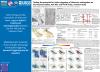
We have identified an active, 140 km long, right lateral fault system that extends through Metropolitan San Diego, from North County to Ensenada. Identification and mapping of fault scarps with a suite of DEM’s and historical maps and 3D mapping of Pleistocene and Eocene unconformities and stratigraphic contacts suggest the segmented fault system includes the previously known La Nacion Fault Zone (LNFZ) and Salsipuedes fault (SF) along coastal Baja, plus a complex array of newly recognized active fault segments, folds and secondary structures. These include a new dextral fault segment that extends 23 km north of the LNFZ from a small pull apart basin in Allied Gardens, a new, 8 km long normal fault/extensional stepover at the US-Mexican Border, a new, 10 km long extensional graben and a new 15 km long dextral segment and linked horsetail splay that offsets the young (5e) marine terrace in Imperial Beach. The Salsipuedes fault extends north of the Border up the coast, where it is marked by pressure ridges in Imperial Beach and along the Silver Strand. An array of oblique splay faults transfers slip on the Salsipuedes eastwards across the South Bay, forming another new diffuse extensional stepover comprised of numerous, west-tilted blocks in Imperial Beach. The large listric normal fault at the Border drives subsidence and first order basin stratigraphic architecture in San Diego Bay and underlies San Diego to the latitude of La Jolla, based on folding of marine terrace platforms. A classic rollover anticline formed in the hangingwall of the normal fault at the Border is marked at its crest with an axial graben that forms Mission Valley, where bending strain is localized. Mapping of faults in Mission Valley using a lidar scale DEM derived from ca. 1953 air photos (i.e. prior to urbanization; see companion abstract by Lopez and Mueller) define dozens of faceted spurs along its southern margin and a fluvial terrace offset ~ 8 m at the I-15. Rupture scenarios for the entire fault system support an Mmax of 7.3, assuming slip does not extend past the 8 km wide stepover at the Border. Offset Holocene deposits are recorded in three locations on the fault system, on the LNFZ, on the Silver Strand at Crown Cove, and at Goat Canyon in the Tijuana River Valley. The linkage of the fault system with the Rose Canyon Fault is unknown, but rollover geometry mapped in the Bay suggest a possible connection with the Coronado Fault.
Citation: Mueller, K. J., & Lopez, W. H. (2024, 09). A Newly Recognized Dextral Fault System in Metropolitan San Diego. Poster Presentation at 2024 SCEC Annual Meeting.
Keywords: Newly Recognized Fault System, San Diego, Seismic Hazard
Relevant SCEC Themes:
Improving Observations and Closing Data Gaps
MORE FROM EARTHQUAKE GEOLOGY

|

|

|

|

|

|
|

|

|
|
|

|

|

|

|
|

|


