Group B, Poster #010, Seismology
Aftershock interferometry illuminates the fault zone beneath the Noto peninsula
Poster Image:

Poster Presentation
2024 SCEC Annual Meeting, Poster #010, SCEC Contribution #13546 VIEW PDF
to the source region and dramatically increases our ability to see into tectonically active features where seismic stations either can't or haven't been located, such as at depth in active fault zones.
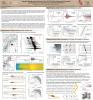
On January 1st, 2024, a large (Mw 7.5) earthquake occurred beneath the Noto Peninsula in Japan, causing extensive damage and affecting tens of thousands of people. This triggered an aftershock sequence with thousands of smaller events extending across the entire peninsula and into the Sea of Japan. On January 3rd, we identified records for dozens of high quality events recorded by the dense Japanese seismic network at sensors 100-300 km away. Green functions were calculated for hundreds of paths, illuminating a section of the fault zone roughly 90 km long and 10 km wide. We inverted the resulting waveforms to create a localized image of the seismic velocity and attenuation structure throughout the crust with kilometer scale lateral resolution.
At the higher resolution, the northeast trending fault trace resolves into a series of sub-parallel fractures. The ratios of seismic attenuation (Qp/Qs) help to identify separate tectonic regimes. In particular the seismogenic zone, defined by the full catalog of events, falls within the contours of higher Qp/Qs which has a topographically complex interface with a deeper, distinctly lower Qp/Qs region. The main event initiated directly above the feature with the lowest Qp/Qs value.
Data were obtained via the National Research Institute for Earth Science and Disaster Resilience (2019), NIED Hi-net, National Research Institute for Earth Science and Disaster Resilience, doi:10.17598/NIED.0003
This work performed under the auspices of the U.S. Department of Energy by Lawrence Livermore National Laboratory under Contract DE-AC52-07NA27344.
SHOW MORE
Citation: Matzel, E. (2024, 09). Aftershock interferometry illuminates the fault zone beneath the Noto peninsula. Poster Presentation at 2024 SCEC Annual Meeting.
Keywords: Noto earthquake, interferometry, virtual seismometers, fault zone imaging
Relevant SCEC Themes:
Improving Observations and Closing Data Gaps
Advanced Modeling Frameworks
Research Computing & Cyberinfrastructure
MORE POSTERS BY THE AUTHORS


MORE FROM SEISMOLOGY

|

|

|

|

|
|

|

|

|

|
|

|

|

|

|

|

|

|

|

|

|
|

|


