Group B, Poster #188, Ground Motions (GM)
The Organizational Process of the Database of Fragile Geologic Features in S.California and Nevada


Poster Image:
Poster Presentation
2024 SCEC Annual Meeting, Poster #188, SCEC Contribution #13840 VIEW PDF
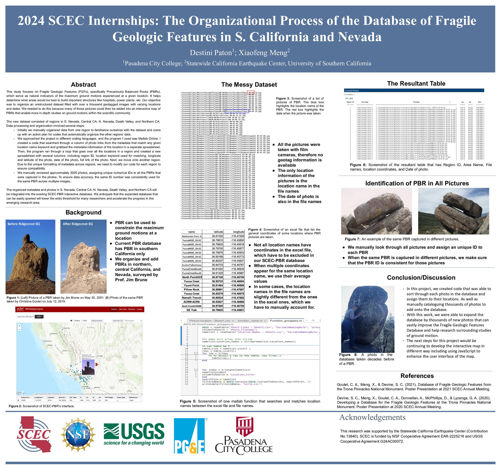
This study focuses on Fragile Geologic Features (FGFs), specifically Precariously Balanced Rocks (PBRs), which serve as natural indicators of the maximum ground motions experienced at a given location. It helps determine what areas would be best to build important structures like hospitals, power plants, etc. Our objective was to organize an unstructured dataset filled with over a thousand geotagged images with varying locations and dates. We needed to do this because many of those pictures could then be added into an interactive map of PBRs that enable more in-depth studies on ground motions within the scientific community.
The new dataset consisted of regions in S. Nevada, Central CA, N. Nevada, Death Valley, and Northern CA. Data processing and organization involved several steps:
Initially we manually organized data from one region to familiarize ourselves with the dataset and come up with an action plan for codes that automatically organize the other regions’ data.
We approached the project in different coding languages, and the program I used was Matlab Online. I created a code that searched through a column of photo links from the metadata that match any given location name keyword and grabbed the metadata information of the location in a separate spreadsheet. Then, the program ran through a loop that goes over all the locations in a region and created a new spreadsheet with several columns, including region ID, location keyword used for matching, longitude and latitude of the photo, date of the photo, full link of the photo. Next, we move onto another region. Due to the unique formatting of metadata across regions, we need to modify our code for each region to ensure compatibility.
We manually reviewed approximately 3000 photos, assigning unique numerical IDs to all the PBRs that were captured in the photos. To ensure data accuracy, the same ID number was consistently used for the same PBR across multiple images..
The organized metadata and photos in S. Nevada, Central CA, N. Nevada, Death Valley, and Northern CA will be integrated into the existing SCEC PBR interactive database. We anticipate that the expanded database that can be easily queried will lower the entry threshold for many researchers and accelerate the progress in this emerging research area.
Citation: Paton, D. M., & Meng, X. (2024, 09). The Organizational Process of the Database of Fragile Geologic Features in S.California and Nevada. Poster Presentation at 2024 SCEC Annual Meeting.
SCEC Award: 24091
Relevant SCEC Themes:
Improving Observations and Closing Data Gaps
Advanced Modeling Frameworks
Improving Predictive Analyses of Seismicity
MORE POSTERS BY THE AUTHORS


MORE FROM GROUND MOTIONS (GM)

|

|

|

|

|

|

|

|

|
|

|

|

|


