Group B, Poster #120, Earthquake Geology
Admitting Failure in the Development of a Holocene Earthquake Record for the Green Valley Fault Zone from a Paleoseismic Site at Siqueira Ranch, Napa County, California

Poster Image:
Poster Presentation
2025 SCEC Annual Meeting, Poster #120, SCEC Contribution #14628 VIEW PDF
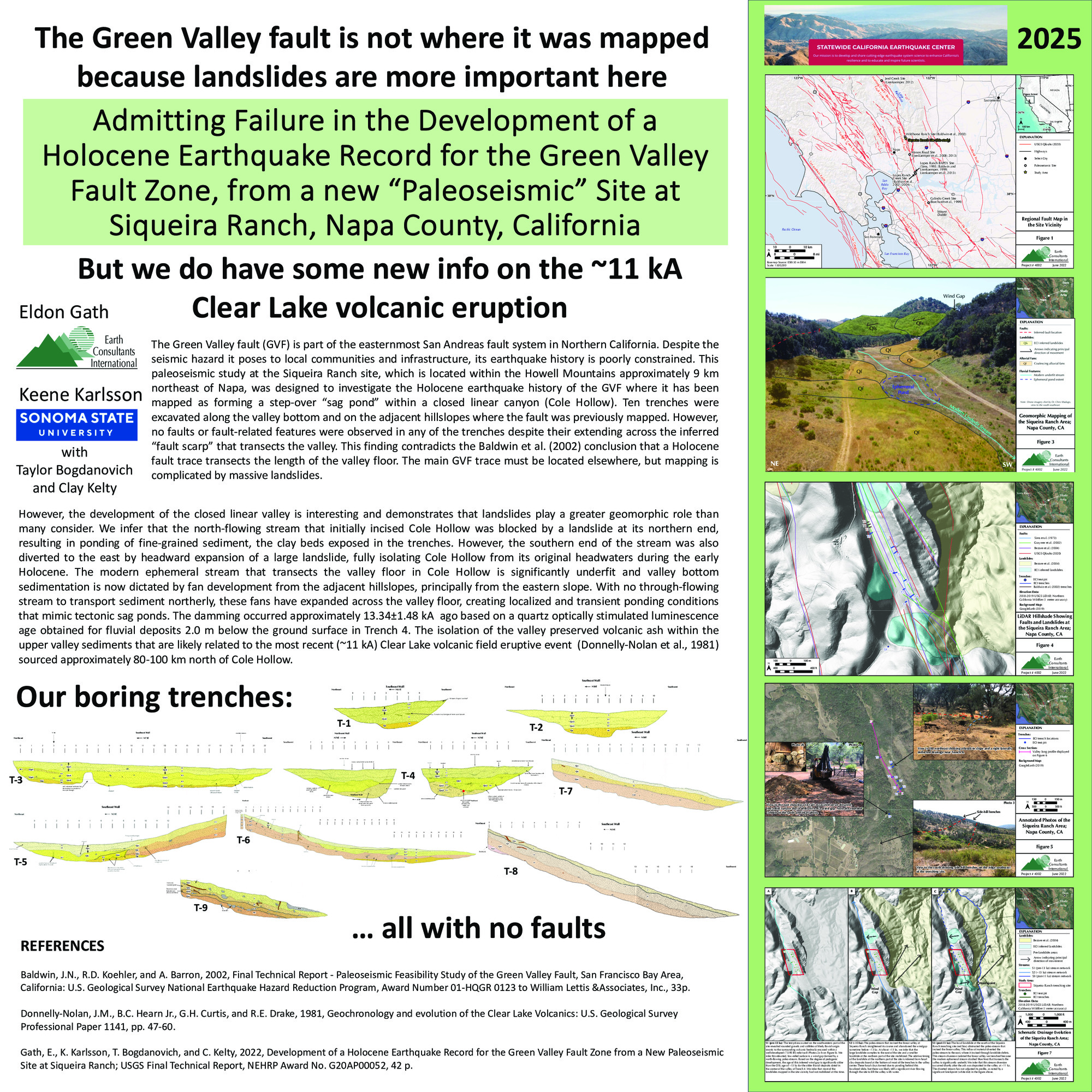
ures were observed in any of the trenches despite their extending across the inferred “fault scarp” that transects the valley. This finding contradicts the Baldwin et al. (2002) conclusion that a Holocene fault trace transects the length of the valley floor. The main GVF trace must be located elsewhere, but mapping is complicated by massive landslides.
However, the development of the closed linear valley is interesting and demonstrates that landslides play a greater geomorphic role than many consider. We infer that the north-flowing stream that initially incised Cole Hollow was blocked by a landslide at its northern end, resulting in ponding of fine-grained sediment, the clay beds exposed in the trenches. However, the southern end of the stream was also diverted to the east by headward expansion of a large landslide, fully isolating Cole Hollow from its original headwaters during the early Holocene. The modern ephemeral stream that transects the valley floor in Cole Hollow is significantly underfit and valley bottom sedimentation is now dictated by fan development from the adjacent hillslopes, principally from the eastern slope. With no through-flowing stream to transport sediment northerly, these fans have expanded across the valley floor, creating localized and transient ponding conditions that mimic tectonic sag ponds. The damming occurred approximately 13.34±1.48 kA based on a quartz optically stimulated luminescence age obtained for fluvial deposits 2.0 m below the ground surface in Trench 4. The isolation of the valley preserved volcanic ash within the upper valley sediments that are likely related to the most recent (~11 kA) Clear Lake volcanic field eruptive event (Donnelly-Nolan et al., 1981) sourced approximately 80-100 km north of Cole Hollow.
SHOW MORE
Citation: Gath, E. M., & Karlsson, K. W. (2025, 09). Admitting Failure in the Development of a Holocene Earthquake Record for the Green Valley Fault Zone from a Paleoseismic Site at Siqueira Ranch, Napa County, California. Poster Presentation at 2025 SCEC Annual Meeting.
Keywords: Tectonic geomorphology, Landslides, Trenching, Napa
Relevant SCEC Themes:
Improving Observations and Closing Data Gaps
MORE FROM EARTHQUAKE GEOLOGY

|

|

|

|

|

|

|

|

|

|

|

|

|

|

|