Group A, Poster #089, Community Earth Models (CEM)
Expansion of the combined GNSS component of the Community Geodetic Model for the Statewide California Earthquake Center


Poster Image:
Poster Presentation
2026 SCEC Annual Meeting, Poster #089, SCEC Contribution #15585 VIEW PDF
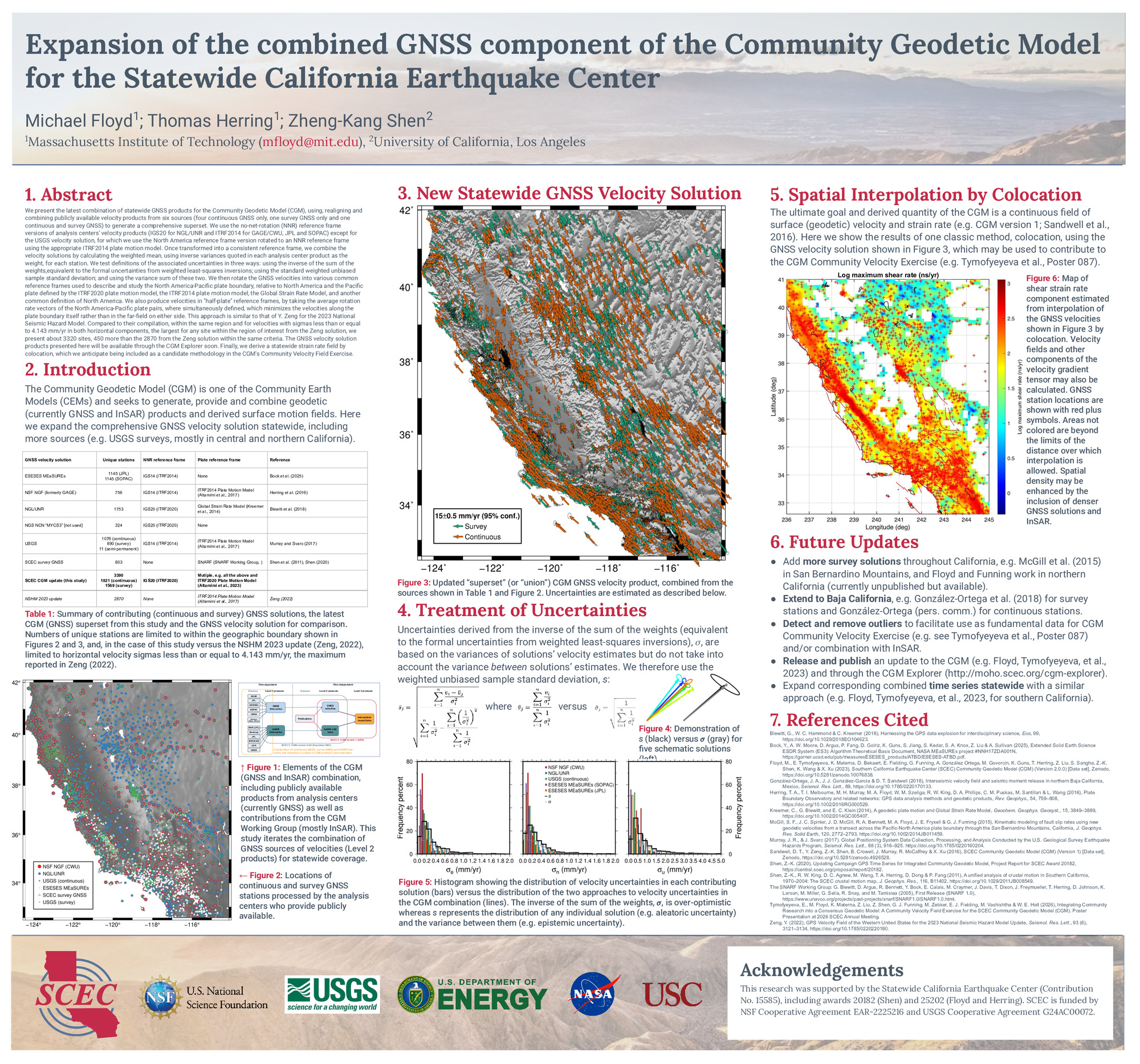
We present the latest combination of statewide GNSS products for the Community Geodetic Model (CGM), using, realigning and combining publicly available velocity products from six sources (four continuous GNSS only, one survey GNSS only and one continuous and survey GNSS) to generate a comprehensive superset. We use the no-net-rotation (NNR) reference frame versions of analysis centers’ velocity products (IGS20 for NGL/UNR and ITRF2014 for GAGE/CWU, JPL and SOPAC) except for the USGS velocity solution, for which we use the North America reference frame version rotated to an NNR reference frame using the appropriate ITRF2014 plate motion model. Once transformed into a consistent reference frame, we combine the velocity solutions by calculating the weighted mean, using inverse variances quoted in each analysis center product as the weight, for each station. We test definitions of the associated uncertainties in three ways: using the inverse of the sum of the weights,equivalent to the formal uncertainties from weighted least-squares inversions; using the standard weighted unbiased sample standard deviation; and using the variance sum of these two. We then rotate the GNSS velocities into various common reference frames used to describe and study the North America-Pacific plate boundary, relative to North America and the Pacific plate defined by the ITRF2020 plate motion model, the ITRF2014 plate motion model, the Global Strain Rate Model, and another common definition of North America. We also produce velocities in "half-plate" reference frames, by taking the average rotation rate vectors of the North America-Pacific plate pairs, where simultaneously defined, which minimizes the velocities along the plate boundary itself rather than in the far-field on either side. This approach is similar to that of Y. Zeng for the 2023 National Seismic Hazard Model. Compared to their compilation, within the same region and for velocities with sigmas less than or equal to 4.143 mm/yr in both horizontal components, the largest for any site within the region of interest from the Zeng solution, we present about 3320 sites, 450 more than the 2870 from the Zeng solution within the same criteria. The GNSS velocity solution products presented here will be available through the CGM Explorer soon. Finally, we derive a statewide strain rate field by colocation, which we anticipate being included as a candidate methodology in the CGM's Community Velocity Field Exercise.
Citation: Floyd, M., Herring, T. A., & Shen, Z. (2026, 08). Expansion of the combined GNSS component of the Community Geodetic Model for the Statewide California Earthquake Center. Poster Presentation at 2026 SCEC Annual Meeting.
Keywords: Community Geodetic Model (CGM), GNSS, statewide, combination
Relevant SCEC Themes:
Advancing Community Earth Models for Hazard Analyses
Rapid Post-Earthquake Investigations & Communications