Poster #007, Earthquake Geology
Preliminary observations of Mw 5.1 Sparta (North Carolina) surface deformation – a first documented Mw 5 instrumental earthquake surface rupture in Eastern USA?
Poster Image:

Poster Presentation
2020 SCEC Annual Meeting, Poster #007, SCEC Contribution #10753 VIEW PDF
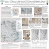
A Mw 5.1 earthquake near Sparta in North Carolina occurred on 08/09/2020. Preliminary estimates by the USGS have its focal depth at 7.6 km with a NW-SE reverse with oblique mechanism. The earthquake is the strongest recorded in North Carolina since the 1916 M 5.2 with an epicenter~170 km to the SW. The shaking in the epicentral area was felt as an intense push with short duration (<5 s). Several fissures trending ~E-W were evident with displacements on the order of a few cm. Right lateral, contractional and extensional indicators were recognized. These include several structures striking consistent 80–90° in a right-stepping echelon pattern crossing the landscape suggesting surface rupture, ~2.3 km NE of the epicenter. A trench perpendicularly dug in the termination of one feature revealed evidence of reverse faulting in its upper few tens of centimeters of the trench, displacing horizontally-bedded Quaternary clays and sands ~10 cm along a fault plane dipping ~19° to the south and creating a vertical offset of ~4 cm. These sediments were overlain by geotextile and ~10–20-cm-thick gravel fill during the construction of the industrial facility. The surface expression of the fault in the trench roots into saprolite beneath about 20 cm of the faulted sediment. The saprolite is developed from the Ashe Metamorphic Suite that here has a fabric dipping 60-70° to the south. At this site, we hand-excavated other similar features also with displacements of sediment and artificial fill at the surface. All features combined, yield a total vertical deformation at this site of ~20 cm and provide evidence for active surface faulting on a reverse fault. This newly identified fault is named the Little River Fault. At another site ~800 m to the SE from this trench similar features are present, but poorly preserved because they were modified by human activity immediately after the earthquake. This site has sediments and is an excellent target for paleoseismological trenching. The field evidence suggests that the surface rupture length is <5 km long on a south dipping structure, consistent with increased damage to infrastructures in the hanging wall. This is consistent with a NE-SW maximum horizontal stress. These observations demonstrate that a Mw 5 earthquake can generate surface rupture with subtle evidence. In low rate tectonic areas where earthquakes are infrequent and evidence poorly preserved, these findings provide a new perspective for seismic hazard analysis.


