Group B, Poster #128, Seismology
The Southern California plate boundary, the San Andreas fault, is traceable as a dipping structure throughout the lithosphere

Poster Image:
Poster Presentation
2026 SCEC Annual Meeting, Poster #128, SCEC Contribution #15454 VIEW PDF
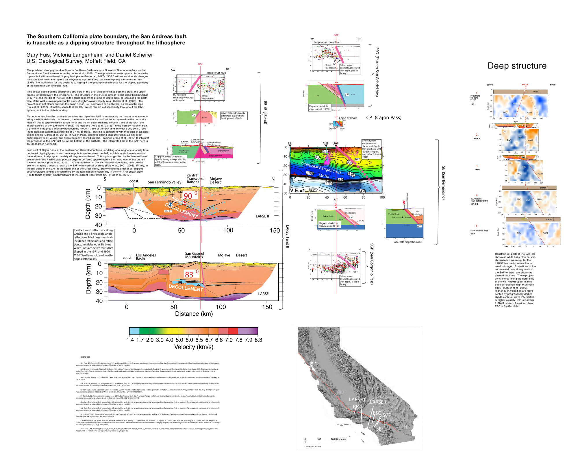
The predicted strong ground motions in Southern California for a Shakeout Scenario rupture on the San Andreas fault (SAF) were reported by Jones et al. (2008). These predictions were updated for a similar rupture but with a northeast dipping fault plane (Fuis et al., 2017). SCEC will soon calculate changes from the 2008 Scenario rupture for a dynamic rupture along this same dipping SAF. The motivation for this poster is to highlight the geophysical evidence for the dipping geometry of the southern SAF.
This poster describes the subsurface structure of the SAF as it penetrates both the crust and upper mantle, or collectively, the lithosphere. The structure in the crust is similar to that described in SCEC CFM 7.0, and the dip of the SAF in the crust appears to project to depth more or less along the north side of the well-known upper-mantle body of high P-wave velocity (e.g., Kohler et al., 2003). The projection is not planar but is in the same sense, i.e., northward or southward, as the crustal dips. It makes sense that the SAF would remain a discontinuity throughout the lithosphere, as it is the plate boundary.
Except as noted, fault dips reported below were first reported in Fuis et al. (2012). Throughout the San Bernardino Mountains, the dip of the SAF is moderately north to northeastward as documented by multiple data sets, including an offset in the base of seismicity, a magnetic anomaly between the modern SAF and an older branch, modeling of ambient noise (Barak et al., 2015), and deep drilling in Cajon Pass (Forand et al., 2017).
Just west of Cajon Pass, in the eastern San Gabriel Mountains, seismicity in the Pacific plate (Cucamonga thrust fault) extends northeast of the current trace of the SAF suggesting a continuation of a moderate northeastward dip. Farther northwest, both LARSE seismic-imaging transects require the SAF to be vertical or steep. Finally, in the Big Bend of the SAF at the south end of the Great Valley, gravity requires a moderate dip southwestward, confirmed by the termination of seismicity in the North American plate (Pleito thrust system) southwestward of the current trace of the SAF.
This poster describes the subsurface structure of the SAF as it penetrates both the crust and upper mantle, or collectively, the lithosphere. The structure in the crust is similar to that described in SCEC CFM 7.0, and the dip of the SAF in the crust appears to project to depth more or less along the north side of the well-known upper-mantle body of high P-wave velocity (e.g., Kohler et al., 2003). The projection is not planar but is in the same sense, i.e., northward or southward, as the crustal dips. It makes sense that the SAF would remain a discontinuity throughout the lithosphere, as it is the plate boundary.
Except as noted, fault dips reported below were first reported in Fuis et al. (2012). Throughout the San Bernardino Mountains, the dip of the SAF is moderately north to northeastward as documented by multiple data sets, including an offset in the base of seismicity, a magnetic anomaly between the modern SAF and an older branch, modeling of ambient noise (Barak et al., 2015), and deep drilling in Cajon Pass (Forand et al., 2017).
Just west of Cajon Pass, in the eastern San Gabriel Mountains, seismicity in the Pacific plate (Cucamonga thrust fault) extends northeast of the current trace of the SAF suggesting a continuation of a moderate northeastward dip. Farther northwest, both LARSE seismic-imaging transects require the SAF to be vertical or steep. Finally, in the Big Bend of the SAF at the south end of the Great Valley, gravity requires a moderate dip southwestward, confirmed by the termination of seismicity in the North American plate (Pleito thrust system) southwestward of the current trace of the SAF.
Citation: Fuis, G. S., Langenheim, V. E., & Scheirer, D. S. (2026, 08). The Southern California plate boundary, the San Andreas fault, is traceable as a dipping structure throughout the lithosphere. Poster Presentation at 2026 SCEC Annual Meeting.
Keywords: San Andreas fault, fault dip, lithosphere
Relevant SCEC Themes:
Earthquake Scenarios for Hazard and Risk Assessment