Group A, Poster #307, Community Capability Building (CCB)
Case Study: A Remote Sensing Approach to Site Selection for an Urban Deployment of Nodal Seismometers
Poster Image:
Poster Presentation
2025 SCEC Annual Meeting, Poster #307, SCEC Contribution #14885 VIEW PDF
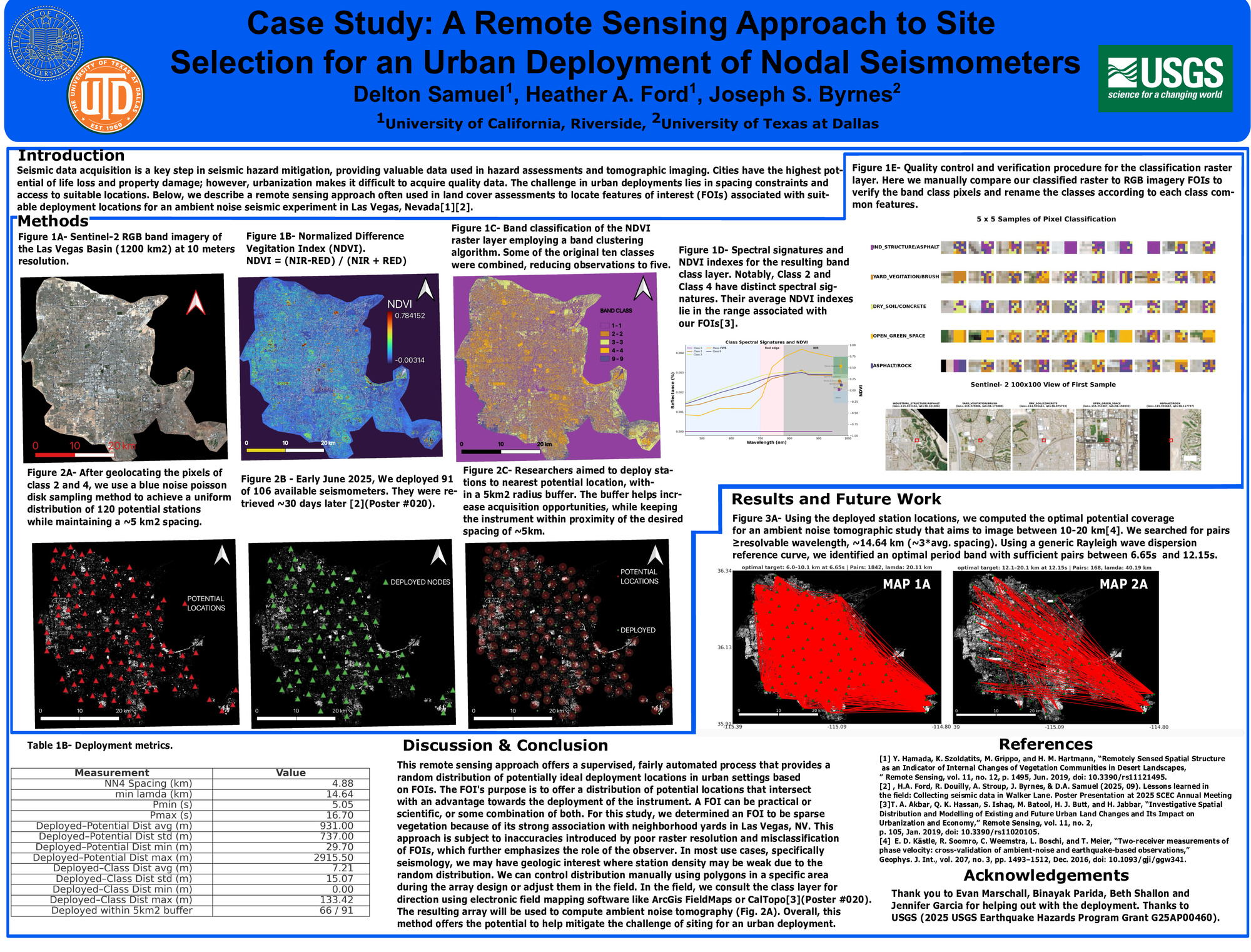
h area, number of instruments, and array complexities. We offer a remote sensing solution, implemented in open-source QGIS, that optimizes the search for potential sites and spatial distribution when designing a passive source study. The motivation for this effort is to utilize the collected passive source seismic recordings to understand the Las Vegas, Nevada basin fault structure employing ambient noise tomographic methods and explore new denoising algorithms. We identify potential node sites based on the desired spacing and research interests sharing a common feature of interest (FOI). For this study, we define a FOI to be sparse, relatively healthy green vegetation in a desert urban environment where a cultural source of upkeep is likely. We associate these areas with an increased potential for collaboration with the community and gaining permission to install a seismometer for ~30 days. Using the RGB and infrared (IR) spectral bands obtained from the Sentinel-2 satellite, we can calculate the Normalized Difference Vegetation Index (NDVI). We extract a layer that classifies the pixels within the NDVI range of our FOIs for further post-processing. We perform a raster transversal to search and locate the classified pixels, logging the latitude and longitude at the centroid of each pixel. We set conditions where each potential station is randomly plotted on a pixel at least 3 km apart, with a 5 km² buffer, to increase acquisition opportunities and help maintain spacing. Between July 8th and 12th, 2025, we deployed 91 of 106 available seismometers with a three-team effort. We achieved an average spacing of ~4 km between the three nearest stations, with a minimum station spacing of ~1.6 km and a maximum station spacing of ~12 km, over an area of ~1200 km².
SHOW MORE
SHOW MORE
Citation: Samuel, D. A., Ford, H. A., & Byrnes, J. (2025, 09). Case Study: A Remote Sensing Approach to Site Selection for an Urban Deployment of Nodal Seismometers. Poster Presentation at 2025 SCEC Annual Meeting.
Keywords: Remote Sensing, Urban Seismology, Seismology, Array Design
Relevant SCEC Themes:
Improving Observations and Closing Data Gaps